Innovations in rainwater collection and water management within tropical environments produced distinctly Mayan societal structure.
 |
| Temple of Grand Jaguar, Tikal |
Regional Climate Context
The Maya shared a common problem with the University of Penn archaeologists that visited the ruins of Tikal centuries later: how do we get consistent, potable water here without nearby lakes and rivers? The Central American rainforest and wetlands offer a myriad of different problems for those looking to inhabit the land, much less rule over it. Solutions for the Maya's water needs arose in a few different forms that share many commonalities. Analysis of objects in Holtzun cenote of Chichen Itza and around the rainwater collection system of the city of Tikal offer many insights into the culture of the Maya.
“Although the southern Maya lowlands may receive as much as eighty inches of rain a year, the rainfall is concentrated in an eight-month season” (Scarborough 40). For perspective, this region receives about twice the amount of yearly rainfall as Austin, Texas, which hovers around 34.25in a year (U.S. Climate Data). Transporting the water over land using burrows or manual labor is treacherous and incredibly inefficient. The Maya were left with no option but to efficiently control their limited water resources. Managing the temperamental water resource meant a series of technological and managerial advances that helped sophisticate all other practices of Maya culture and economy.
“Although the southern Maya lowlands may receive as much as eighty inches of rain a year, the rainfall is concentrated in an eight-month season” (Scarborough 40). For perspective, this region receives about twice the amount of yearly rainfall as Austin, Texas, which hovers around 34.25in a year (U.S. Climate Data). Transporting the water over land using burrows or manual labor is treacherous and incredibly inefficient. The Maya were left with no option but to efficiently control their limited water resources. Managing the temperamental water resource meant a series of technological and managerial advances that helped sophisticate all other practices of Maya culture and economy.
Cenotes
Cenotes are deep underground caverns able to collect and hold water. Many are still able to be visited today. Cenotes represent a source of water that is large and clean enough to sustain human life. Moreover, they signaled high quality soil and the presence of local water tables, making the surrounding area attractive for agriculture. Not surprisingly, cenotes became centers of Mayan life on the Yucatan lowlands and are “often found near ancient sites such as Chichen Itza” (Luzzadder-Beach 435).
Many times, access to the water was difficult. In the case of the Holtun Cenote, outside of Chichen Itza, the opening was 3 meters by 2.7 meters (about 9x9ft). Those tasked with entering the cenote "probably used ropes to slide down from the ground surface to reach the water" and "some sort of flotation device" to navigate the water surface (Cobos 59). The water source was not accessible to the majority of the population for more than just the small opening. The cenote represented major religious significance for the Mayans. With religion tied directly to the societal hierarchy, the cenote's value became more sentimental and religious than functional. Items found within the well shed light on activities that took place in and around the Holtun cenote adjacent to Chichen Itza in the Late Preclassic age.

Two types of items could be found in the Holtun cenote. The first image (Object #1) shows ancient ceramics found upon a ledge in the Holtun cenote. The ledges can be seen in the above artist's rendering of the subterranean basin. As opposed to the objects found at the bottom of the basin, cultural artifacts found on the ledge "were placed [on 16 meters of limestone] when that surface was dry and the water level was below this feature" (Cobos 60). The objects were presumably arranged by a person lowered into the cenote. The items features a diverse set of items ranging from eight different ceramic types to human and animal bones.
The second type of objects found within the Holtun cenote were found at the very bottom of the basin. "These objects were thrown from the ground entrance into the cenote waters" as religious offerings (Cobos 60). These objects, such as the one pictured above, are often broken but salvageable and display effects of remaining underwater.
Cenotes provide insight into the Mayan understanding of water management from a functional and societal standpoint. Functionally, the Maya appear to understand conservation of a static water source, as opposed to access to flowing rivers or natural lakes. However, cenotes do not indicate an elevated knowledge of capturing rainfall and employing gravity to deliver water. Societally, the display of cultural importance and elite exclusivity which is consistent with other water management techniques. Its' believed religious value and ceremonial importance display a distancing of the masses from the water source. Reservoirs demonstrate the functional dependency the Maya elite's create and maintain.
 |
| Nat Geo divers swimming in the illuminated Holtun Cenote http://www.natgeocreative.com/comp/MM8/150/1575692.jpg |

 |
| Objects #1 (above) & #2 (below) - Vases found within Holtun cenote |
The second type of objects found within the Holtun cenote were found at the very bottom of the basin. "These objects were thrown from the ground entrance into the cenote waters" as religious offerings (Cobos 60). These objects, such as the one pictured above, are often broken but salvageable and display effects of remaining underwater.
Cenotes provide insight into the Mayan understanding of water management from a functional and societal standpoint. Functionally, the Maya appear to understand conservation of a static water source, as opposed to access to flowing rivers or natural lakes. However, cenotes do not indicate an elevated knowledge of capturing rainfall and employing gravity to deliver water. Societally, the display of cultural importance and elite exclusivity which is consistent with other water management techniques. Its' believed religious value and ceremonial importance display a distancing of the masses from the water source. Reservoirs demonstrate the functional dependency the Maya elite's create and maintain.
Reservoirs - Aguandas
 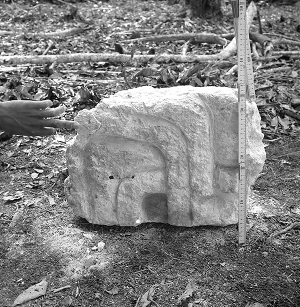 |
| Object #3 Laja Dennis Puleston, University of Pennsylvania Tikal Project Negative 64-37-112, University of Pennsylvania Museum. All rights reserved. |
Tikal's towering structures were built with quarried rock. Many Mayan quarries were located directly adjacent to the city. Quarries, in turn, were made into reservoirs easily, the rock being employed to improve water retention levels. This effective strategy produced the literal building blocks of Mayan architecture, such as this block pictured above. These slabs, or lajas, would be held together "by thick black clays that did not allow water to seep through the bottom" (Harrison 23). These slabs made up the foundation of most of city's structures, including three major reservoirs depicted below. This represents a major augmentation of the land by the Maya people as well as an implicit cultural understanding of regulation authority needed in the new complex water system.
 |
| Demonstration of slop and strata of Tikal water reservoirs (Harrison 23) |
Tikal Reservoir Examples
 |
| Object #4 Excavated dike, 1962 (Harrison 23) |
The above picture depicts Jose Leva, a Guatemalan archaeologist atop an excavated dike connecting two reservoirs in Tikal. This picture demonstrates the slope factor which Maya engineers took advantage of to transport the collected water. Dikes were among several different water release and retention mechanisms employed in Tikal. They represent not only a complex understanding of gravity and its application, but also of a great understanding of weather patterns. "As the engineers of the water managements system monitored the seasonal patterns and amounts of rainfall, they accordingly created the system of water retention with large and small water basins" (Harrison23). Moreover, these dikes contain stair step-like features that allow researchers to understand water "marking levels that were sustained for long periods of time" (Harrison 24).

 |
| Object #5: Exposed water canal (Scarborough) |
This picture shows a canal that moves water towards the Corriental reservoir, the final stage of the Temple water's travel. The Corriental was "one of four bajo-margin tanks situated just above isolated, seasonally inundated depressions (bajos) that were likely the foci of intensive farming" (Scarborough 12411). This represents the end of the formalized network of water allocation. By this point, the water has been assumed to be at its worst quality. This is the transition of water from the system to the farming field and was most likely used to maintain wetlands (Chinampas) that many have understood the Maya to have used. This system ultimately created a tremendously large society, estimated at 9,800, who were largely dependent on the knowledge and decision making of the elite class in order to survive. The Maya population could only scale both upwards and downwards spatially by surplus of water or by more efficient and complex collection methods. The water retained its' religious ties but precipitation declines ultimately led to the end of this great society.

Thank you.
Works Cited
Austin Climate Data. US Climate Data. "Temperature - Precipitation - Sunshine - Snowfall."Climate Texas. N.p., n.d. Web. 04 Oct. 2016.
Cobos, Rafael, Guillermo De Anda Alanís, and Roberto García Moll. "5 Ancient Climate and Archaeology: Uxmal, Chichén Itzá, and Their Collapse at the End of the Terminal Classic Period." Archeological Papers of the American Anthropological Association 24.1 (2014): 56-71. Web.
Http://independent.academia.edu/PeterHarrison1. "A Marvel of Maya Engineering: Water Management at Tikal - in Expedition, Vol. 54, No. 2, Pp. 19-26." Academia.edu. N.p., n.d. Web. 03 Oct. 2016.
Lucero, Lisa J., Scott L. Fedick, Nicholas P. Dunning, David L. Lentz, and Vernon L. Scarborough. "3 Water and Landscape: Ancient Maya Settlement Decisions." Archeological Papers of the American Anthropological Association 24.1 (2014): 30-42. Web.
Luzzadder-Beach, Sheryl, Timothy Beach, Scott Hutson, and Samantha Krause. "Sky-earth, Lake-sea: Climate and Water in Maya History and Landscape." Antiquity 90.350 (2016): 426-42. Web.
Scarborough, V. L., N. P. Dunning, K. B. Tankersley, C. Carr, E. Weaver, L. Grazioso, B. Lane, J. G. Jones, P. Buttles, F. Valdez, and D. L. Lentz. "Water and Sustainable Land Use at the Ancient Tropical City of Tikal, Guatemala."Proceedings of the National Academy of Sciences 109.31 (2012): 12408-2413. Web.
Scarborough, Vernon L. "Flow Of Power." The Sciences 32.2 (1992): 38-43. Web.
Austin Climate Data. US Climate Data. "Temperature - Precipitation - Sunshine - Snowfall."Climate Texas. N.p., n.d. Web. 04 Oct. 2016.
Cobos, Rafael, Guillermo De Anda Alanís, and Roberto García Moll. "5 Ancient Climate and Archaeology: Uxmal, Chichén Itzá, and Their Collapse at the End of the Terminal Classic Period." Archeological Papers of the American Anthropological Association 24.1 (2014): 56-71. Web.